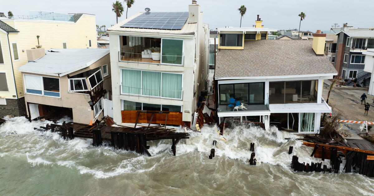
With homes nearly toppling into the ocean and back-to-back floods and hurricanes amplifying our sense of dread, keeping track of all things El Niño can be overwhelming.
So I called up Patrick Barnard, who spent years leading the U.S. Geological Survey’s renowned coastal hazards team in California and now helms key climate adaptation research at UC Santa Cruz. A maestro at bringing together all manner of data, Barnard broke down the numbers in no-nonsense terms — explaining why the coming weeks and months might bring extreme flooding like we’ve never seen before.
“All the stars are aligning for a pretty dramatic winter,” said Barnard, as he pored over the El Niño tea leaves, so to speak, and rattled off every high tide phenomenon on track to converge by the holidays. “If you start stacking all these things up, the flood risk just goes up exponentially.”
To start, the waters off the California coast have been the hottest they have ever been at this time of year. Multiple temperature records have been shattered, and an intense marine heat wave has been churning since last December — making our typical high tides even higher — El Niño notwithstanding.
Warm water, put simply, expands, whereas cold water takes up less space. And this heat wave alone, Barnard explained, has already made sea level rise temporarily by about 6 inches.
Now add El Niño on top of these 6 inches. Historically, El Niño can raise water levels along the West Coast by an additional 6 to 12 inches throughout the winter, and key indicators for this season are already pointing to a supercharged El Niño.
(Think of El Niño as a reverse swing in global weather patterns that can make the ocean much hotter in parts of the world where it shouldn’t be. This can turn cold places warm, unleash downpours in typically dry regions and throw other climate phenomena out of whack — like bringing hurricanes too close for comfort in California.)
So California is now facing possibly 18 inches, or 1.5 feet, of sea level rise, but we’re not done yet: This winter also happens to be nearing the peak of both a 4.4-year high tide cycle and a lunar nodal cycle that occurs every 18.6 years, which will add a few more inches of sea level rise.
“It basically adds about 2 to 4 inches on top of everything else — it doesn’t sound like a lot, but 2 to 4 inches doubles the flood frequency in California,” Barnard said, citing a pivotal global study that quantified how flood frequency changes with sea level rise. “So that’s another factor that’s essentially doubling the flood risk. And with the heat wave, plus El Niño, plus the tides, think about how many times over you’ve doubled it now.”
Then there’s the Kelvin wave, a massive, slow-moving bulge of water that essentially thickens the surface layer of the ocean and can add another 6 to 12 inches of sea level rise as it passes through. So double, perhaps quadruple, the flood risk again. Just this past week, a Kelvin wave proved to be quite the flood amplifier in Long Beach and Newport Beach, and scientists say there’s another on the way. (A key factor in El Niño’s development, Kelvin waves were first described by Lord Kelvin, the same scientist who invented the Kelvin scale, the international system of absolute temperature.)
Add to all this the infamous king tide, which usually brings dramatic flooding to California a few times each winter and can add another 12 inches, possibly more, to an already-high tide.
These astronomical high tides are quite predictable, and as the orbits of the moon and sun and Earth would have it, three of the highest tides in recorded history are expected to hit California around Thanksgiving, Christmas and the week of Martin Luther King Jr. Day:
- Nov. 24 to 26, 2026
- Dec. 23 to 25, 2026
- Jan. 21 to 22, 2027
What remains to be seen is whether a winter storm or another Kelvin wave will coincide with any of these three king tides.
The wave-shattered homes and boardwalks of this past week are a visceral glimpse into what a few additional feet of sea level rise could look like in California. To help visualize this further, consider the general rule of thumb that 1 foot of sea level rise could push the ocean inland as much as the length of a football field. Anything in the way of that shifting line in the sand — a seawall, a road or sand berm — would have to hold against the pressure of that much water trying to move in.
After the last particularly intense El Niño, during the 2015-16 winter season, Barnard and a network of scientists assessed the damage along the West Coast and found that shoreline retreat — or how much the beach disappeared — was an eye-popping 76% higher than in a typical winter. Researchers also found that wave energy was 50% higher, with some of the largest individual waves measuring more than 63 feet off Mendocino and 55 feet off Point Reyes during a December 2015 storm.
So at what point can we still call this an emergency if we know the water is coming? Coastal planners have been talking for years about preparing for these existential challenges, and proponents of nature-based solutions have been sounding the alarm on the need to revive our vanishing beaches and wetlands — the shoreline’s original buffers from the sea. A law signed by Gov. Gavin Newsom in 2023 requires every coastal city and county in California to develop a sea level rise plan by 2034, and more than a dozen key agencies have agreed that California needs to prepare for at least 3.5 feet of sea level rise by 2050.
All these higher-than-high tides might feel like inauspicious one-offs, but this El Niño season should be considered practice for the future. As Barnard puts it: “This is what it’s going to look like every winter, in less than a generation.”
Barnard, whose research has been used by more than 200 government agencies across the West Coast and beyond, said he hopes this year’s El Niño will shake people out of repeating the same knee-jerk reactions of building seawalls and other increasingly futile defenses against the rising sea. Could communities instead shift into longer-term thinking about how to work with nature — and adapt with the realities of a changing landscape?
“It’s time to stop putting band-aids on things and just accept that these bigger flood events are going to be much more commonplace in the future,” said Barnard, who now serves as research director at UC Santa Cruz’s Center for Coastal Climate Resilience.
“Any preparations we take now, any kind of planning that we do for climate change — whether we’re restoring dunes or restoring tidal marshes or getting out of the way — it’s going to pay off immediately, as well as down the line. … It’s really time to think long term about how we’re going to manage our coast more effectively.”
More ocean news
Alaska pollock, the fish behind imitation crab and America’s fish sticks, is fueling a fight over trawling and bycatch. Annika Hammerschlag at the Associated Press breaks down this controversy with the world’s second-largest fishery.
Also check out this big investigation from Ian Urbina and The Outlaw Ocean Project, which goes deep into pollution, labor abuses and the hidden costs of seafood farms — and their role in depleting wild fish populations through the “fishmeal” being fed to farm-raised fish.
Come talk sea level rise with me
I’m giving the keynote at the 2026 Bay Adapt Summit: Rising Together, which takes place on Monday, Nov. 9, at the Exploratorium in San Francisco. It is an annual gathering of sea level rise adaptation practitioners and community members, and the panel discussions are open to the public.
I will also be joining Malcolm Clemens Young, Dean of Grace Cathedral, on Sunday, Nov. 8, for the Forum series, and the San Francisco Public Library is hosting a book discussion of “California Against the Sea” on Saturday, Dec. 5, as part of the library’s One City One Book program. I will be in conversation with Marina Psaros, author of “The Atlas of Disappearing Places: Our Coasts and Oceans in the Climate Crisis.”
One more thing
The Marjorie Luke Theater in Santa Barbara will be doing a special screening on Sunday, Oct. 25, of “Out of Plain Sight,” the documentary I directed with Daniel Straub. The film is a cinematic expansion of my reporting on the legacy of DDT and toxic waste dumping off the California coast, and I am grateful to see this story inspiring legislators in Congress and resonating with audiences across the world.
The screening starts at 4 p.m., and I will be there for a post-screening discussion featuring scientists from UC Santa Barbara, Scripps Institution of Oceanography at UC San Diego, the Pacific Marine Mammal Center and San Diego State’s School of Public Health.
This is the latest edition of Boiling Point, a newsletter about climate change and the environment in the American West. Sign up here to get it in your inbox.
And be sure to tune in to the Boiling Point podcast: In this week’s episode, Times reporter Blanca Begert speaks with host Miranda Green about how the data center boom is driving immense pushback in California. Green also speaks with Cassie Buhler, a researcher at UC Berkeley who says there may already be an alternative to commercial AI that uses roughly 100 times less power.
For more coastal and ocean stories, follow @rosanna.xia and @outofplainsightfilm on Instagram.