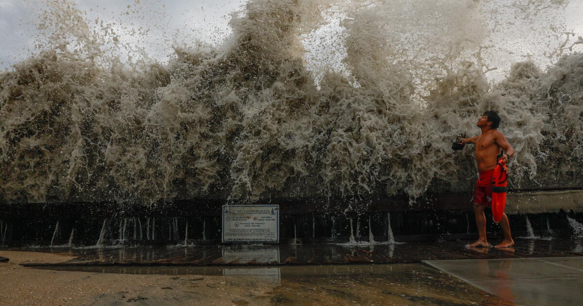
Days of more intense weather are ahead — extreme heat and high humidity — after a dramatic weekend of coastal flooding, rain and dangerously high surf brought by remnants of Tropical Storm Marie.
A big jump in temperature is expected by Tuesday, with heat “10 to 20 degrees above normal” starting to build across even coastal parts of the region. Downtown Los Angeles and Long Beach could see a high of 96 to 98 degrees, and communities farther inland and into the valleys could expect temperatures to reach more than 105.
There will be little relief at night, when the region usually cools down. Low temperatures for Tuesday evening will probably stay in the mid-70s across the Los Angeles Basin, and weather forecasters say Wednesday might be even warmer.
“The still-lingering moisture from Marie, combined with the heat, will add to the heat discomfort and create added heat stress,” said David Gomberg, lead meteorologist at the National Weather Service in Los Angeles-Oxnard, which issued a heat advisory for Wednesday and Thursday and is on alert to ramp up the warnings if the week gets worse.
“If the clouds don’t materialize, then Wednesday could be a real problem, and temperatures could really jump up,” said Gomberg, who reminded people to drink plenty of fluids, stay in air-conditioned rooms and check up on vulnerable relatives and neighbors.
People walk through a flooded street during hide tide on Ocean Boulevard on the Alamitos Peninsula in Long Beach.
(Ronaldo Bolaños / Los Angeles Times)
High surf and coastal flooding advisories also remain in place until 11 p.m. Tuesday, with weather officials urging extreme caution as the ocean continues to churn from the remnants of Tropical Storm Marie.
The rip currents and massive surf are capable of capsizing small boats, knocking people off jetties and pulling swimmers out to sea.
“Anybody who’s inexperienced needs to stay away from the surf zone right now. The waves — sometimes they’ll start out looking kind of moderate, and then all of a sudden, you get these really large, dangerous, higher waves,” Gomberg said. “And the extremely strong rip currents — the last couple days they’ve been numerous, and they’ve been frequent in terms of severity. That’s really dangerous, and that’s why we use the headline ‘potentially life-threatening rip currents.’ ”
In Malibu, waves at Zuma Beach broke as high as 12 feet over the weekend. Emergency responders also scrambled to respond to major beach closures and significant flooding along the coast.
South-facing beaches in Long Beach and Malibu were hit particularly hard by a combination of high swells, higher-than-high tides and tropical-storm-charged waves.
Dramatic video footage from Long Beach shows massive waves slamming into the shoreline and splintering the wood on the boardwalk. Sand berms that had been built ahead of the storm were completely washed away.

Mark Roslawski and his dog, Benni, walk through a flooded parking lot near the Seal Beach Pier.
(Jason Armond / Los Angeles Times)
Residents in the area reported power shortages, flooded garages and drains clogged with sand.
“There’s power shortages going on, so some people are getting shocked in there, so we’re having to turn off all the power. There’s tiles being ripped off the floor, furniture being moved,” Long Beach resident Cole Hill told ABC-7 news.
Tropical storms are not necessarily unusual this time of year for Southern California, but what’s particularly striking about the flooding this week is the confluence of powerful waves on top of higher-than-high tides.
Simply put, cold water takes up less volume and warm water expands — and given the record-breaking heat wave in the ocean that has been parked off the California coast (not to mention the brewing “super” El Niño,) the tides coming in have been higher than a so-called normal season.
High tide levels can fluctuate in this region: they can sometimes be 4 or 5 feet, and sometimes the high tide can reach 6 to 6.5 feet around this time of year.

Resident David Black carries beach towels out of his flooded garage on the Alamitos Peninsula in Long Beach.
(Ronaldo Bolaños /Los Angeles Times)
But high tide on Sunday was 6.7 feet and is forecast to surge as high as 7 feet on Monday evening, and 7.2 feet on Tuesday.
“We’ve been running a little bit higher than the predicted tides, so instead of 6 to 6.5 feet, it’s 6.5 to 7 — and just that little difference in the water level can make a difference of how far inland the water can push near the coast,” Gomberg said.
The rainfall — also unusual for this time of year — did not help with drainage issues over the weekend. Some parts of Los Angeles County received more than 1.25 inches of rain on Sunday.
Across Los Angeles County, public health officials urged beachgoers to avoid swimming in the ocean through Wednesday because of potential bacteria spikes from the rain.
Topographically, Los Angeles County is like a giant bowl tilted toward the sea. Whenever it rains, water rushes down streets and sidewalks — picking up any trash, pesticides, dog poop and other fecal matter in its way. Unlike our sewage, which is filtered through treatment facilities before it’s discharged, this mix of rainwater and debris flushes straight into the ocean through a network of storm drains and concrete-lined rivers.
A good rule of thumb is to wait 72 hours after it rains before going into the ocean. Some scientists recommend five days, especially if the beach is close to an area where a river or an outfall dumps into the ocean.